PLATFORM ACTIVE • TRUSTED BY MUNICIPAL CORPORATIONS & GOVTECH INITIATIVES
Language:
Waste Platform (Live) Ecosystem & CAD Mobile Apps Operational Reports Pricing & Plans How It Works Citizen Portal
30-Day Free Trial Staff Sign In
PROVEN IN PRODUCTION // TRUSTED BY MUNICIPALITIES & GOVTECH

The Geospatial Operations OS for Smart Cities

Powering municipal governance, emergency dispatch, and corporate logistics with sub-second GIS telemetry, offline turn-by-turn navigation, automated multi-stop dispatch, and verified digital proof-of-work.

99.8% Telemetry Uptime
< 850ms Dispatch Latency
18–25% Fuel Cost Reduction
100% Offline PWA Resilient
SECTOR: KPK-TACTICAL-GRID // SAT-LOCK: 14 SVs
LATENCY: 42ms
DT-002 • 28 km/h
EMERGENCY • CAD DISPATCH
SUP-07 • PATROL
BIN-312 • 94% FULL
LIVE ROUTE Compactor DT-002 completed Stop #14 (Swat Depot) 12s ago
CAD DISPATCH Emergency Unit RES-04 geofence alert (Sector A) 45s ago
PROOF OF WORK Verified cleanup uploaded for Complaint #KP-1082 1m ago
FLAGSHIP LIVE SOLUTION • FULLY OPERATIONAL

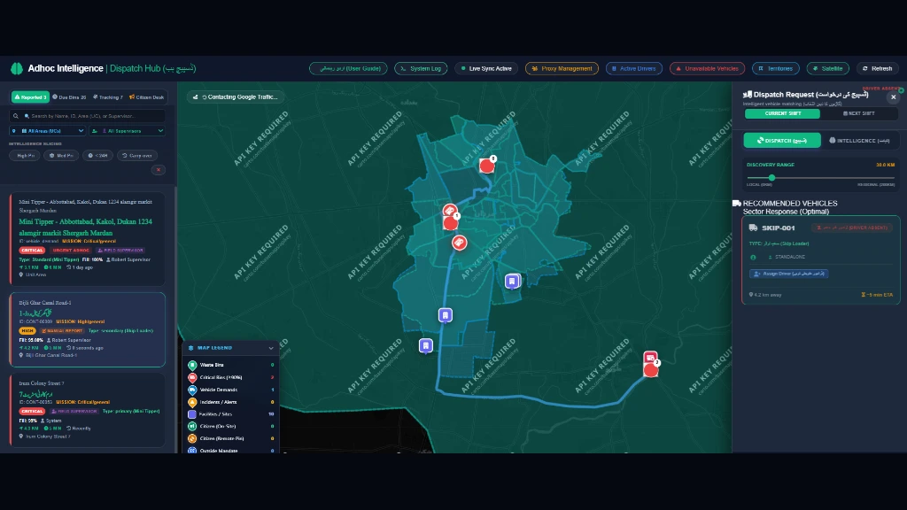
Smart Municipal Waste & Fleet Management

The battle-tested core of MyMaan, actively serving Water & Sanitation Services Companies (WSSCs), Municipal Corporations, and private waste contractors across Pakistan.
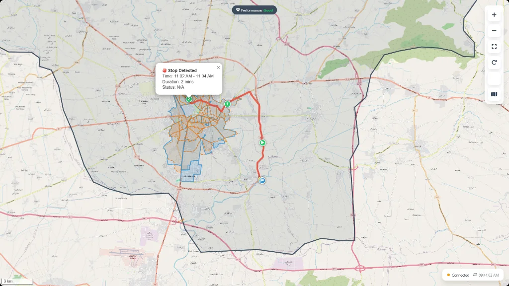
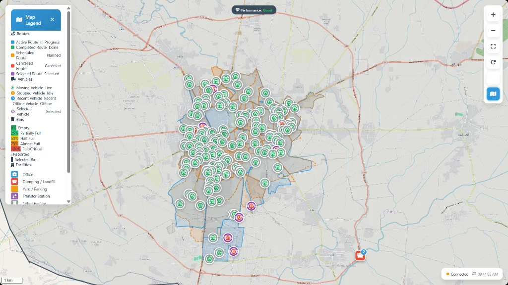
MISSION ACTIVE • WAYPOINTS AUDITED
Mission Route Tracking, Sequence Playback and Stop Duration Auditing
Start-to-Finish Waypoint Sequence Enforcement
Automated Stop Duration Auditing (2-min, 5-min halts)
Verifiable GPS Breadcrumbs (Eliminates Fake Mileage)

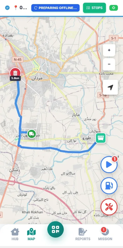
Offline Driver PWA

High-contrast turn-by-turn navigation with audio announcements, sequence compliance, and instant photo capture. Operates 100% offline in remote zones with automated cloud synchronization.

Offline Data Vault Active

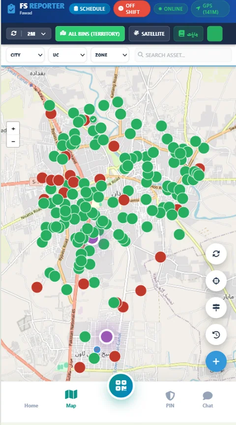
Supervisor Tactical Hub

Real-time GPS breadcrumbs, speed alerts, stop dwell-time monitoring, and automatic odometer reconciliation. Field supervisors reassign tasks and manage sweeps on the fly.

Sub-Second Live GPS

Citizen Grievance Portal

Zero-login public reporting portal. Citizens report overflowing bins or illegal dumps with instant camera photos and GPS coordinates. Every resolution requires verified before/after proof.

Public Zero-Login Tracking

Multi-Tenant Fleet Depots

Full cryptographic company isolation. Manage multiple operational yards, dispatch centers, custom vehicle categories, fuel consumption audits, and daily performance manifests.
Instant Self-Onboarding

Ready to Deploy in Your Municipality or Private Fleet?

Experience the complete waste management intelligence platform live. Provision your company in under 60 seconds with our 30-day all-inclusive free trial.

ENTERPRISE ROADMAP • IN ACTIVE R&D

One Spatial Core, Multiple Mission Critical Verticals

Built upon the proven MyMaan Geospatial Engine, our modular architecture effortlessly scales to emergency services, corporate supply chains, and complex spatial infrastructure.

PILOT PHASE // IN R&D

Emergency Services CAD & Tactical Dispatch

Comprehensive Computer-Aided Dispatch (CAD) designed for high-stress emergency services. Rapid caller location triangulation and automated nearest-responder routing.

  • Rapid caller intake & GPS triangulation
  • Nearest ambulance automated geofenced dispatch
  • Turn-by-turn emergency navigation with priority routing
  • Second-by-second incident timeline & hospital handover
IN DEVELOPMENT

Enterprise Fleet Telematics

High-precision logistics management for commercial transport, distribution corporations, and government utility fleets.

  • Algorithmic fuel theft & drain detection
  • CANbus/OBD engine health & diagnostics
  • Driver safety scorecard (harsh braking, idling)
  • Automated preventative maintenance & DVIR checklists
CUSTOM SPATIAL GIS

Urban GIS & Spatial Utilities

Tailored spatial information systems for public works, water distribution boards, electrical networks, and urban master planning.

  • Water supply, valve & underground pipeline mapping
  • Offline mobile GIS field surveyor tool
  • Spatial heatmaps, polygon zoning & land use overlays
  • Enterprise PostGIS spatial querying engine
FIELD-READY OPERATIONAL APPS

Official Mobile Apps on Google Play & PWA

Equip your front-line personnel with dedicated high-performance Android applications built for real-time telemetry, offline execution, and sub-second dispatch.

MyMaan Driver App

Native Android & PWA for Municipal Waste Collection & Fleet Crews

v3.4 Production Ready 100% Offline Capable
  • Offline turn-by-turn navigation with audio route prompts
  • Mandatory geotagged camera photos (before & after collection)
  • Offline IndexedDB vault storing entire route with zero network
  • Instant auto-sync to central PostGIS server when back online
MyMaan Driver Navigation App Interface
Live Driver Cockpit

MyMaan Field Supervisor

Tactical Command & Patrol App for Ward Inspectors & Fleet Officers

v3.4 Production Ready Sub-Second Telematics
  • Sub-second live vehicle telemetry, speed & dwell-time radar
  • On-the-fly emergency dispatch & ad-hoc complaint re-routing
  • Driver attendance verification & geofenced depot check-in
  • Fuel drain detection, idling violations & street sweep audits
MyMaan Field Supervisor Tactical Map Interface
Tactical Patrol Radar
ENTERPRISE AUDIT & TELEMETRY SUITE

Operational Reports & Analytics Engine

Legally defensible audit trails, real-time odometer reconciliation, cross-yard benchmarking, and tamper-proof field proof-of-work — engineered for municipal oversight, contractor SLA verification, and zero fuel sensor hardware dependencies.

142.8 km
GPS Breadcrumb Track
99.8%
Odometer Match Rate
97.4%
Corridor Compliance
1,420+
Photo Proofs Sealed

Vehicle Performance

AUDIT TRAIL // ODOMETER VS GPS
Odometer Reconciled

Automatically audits and reconciles vehicle odometers against exact satellite GPS track lengths to prevent inflated manual fuel vouchers. Monitors active mission duty windows, speed compliance, and collection stop durations.

VEHICLE: CMP-104 (12m³ COMPACTOR) ZONE-1 OPERATIONAL
GPS Verified Track: 84.6 km
Driver Odometer Log: 84.9 km (99.6% Match)
Active Mission Window: 5 hrs 22 mins • Moving: 4h 12m
Audit Reconciliation: Passed • Zero Discrepancy
  • Multi-Point Mission Odometer Reconciliation: Audits Start & End odometers across every mission leg (e.g. 10 checkpoints for 5 missions) plus fueling logs against GPS tracks to eliminate paper voucher inflation and inter-mission ghost mileage.
  • Operational Duty Windows: Tracks verified mission duty cycles, active transit hours, and bin collection dwell times without intrusive vehicle wiring.
  • Automated Stop Audits: Quantifies dwell-time at bins (e.g. 2-min stops) vs unauthorized halts.
PDF • Excel • CSV Access in Console

Fleet Comparison

CROSS-FLEET BENCHMARKING & SCORING
Comparative KPI

Side-by-side comparative analytics across machinery types, multi-zone operational yards, and contractor shifts. Benchmarks utilization index and cost per kilometer to isolate underperforming assets.

CROSS-YARD COMPARISON • MONTHLY BENCHMARK ACTIVE AUDIT
Zone-1 Compactors (12 Units): 92.4% Active Utilization
Zone-2 Mini-Dumpers (8 Units): 87.1% Active Utilization
Cost Normalized / Km: Zone-1: Rs. 42/km • Zone-2: Rs. 38/km
Shift Performance Score: Morning Shift 96.2% SLA
  • Utilization Index: Measures productive collection sweeps vs stationary yard time across entire fleet.
  • Yard-by-Yard Benchmarking: Compares efficiency between different operational yards and contractor depots.
  • Rogue Asset Flagging: Highlights vehicles exhibiting recurring path anomalies or off-duty movements.
XLSX • CSV • Bi-Weekly Access in Console

Route Compliance

CORRIDOR SEQUENCE & GEOFENCE AUDIT
Corridor Enforced

Verifies whether collection trucks followed the exact designated street corridors and bin sequence. Detects skipped containers, unauthorized deviations, and off-route moonlighting trips with proof.

MISSION AUDIT: WARD-04 MORNING SWEEP ROUTE-A CORRIDOR
Corridor Adherence: 98.2% Planned Path Covered
Container Sequence: 34 of 34 Bins Swept (0 Skipped)
Out-of-Boundary Breaches: 0 Unauthorized Deviations
Contractor Billing SLA: 100% Invoice Clearance Approved
  • Street Corridor Adherence: Algorithmic polygon matching ensuring no street in the ward is neglected.
  • Chronological Bin Verification: Verifies every waypoint stop in sequential order from Start to Finish.
  • Deduction & Penalty Safeguards: Generates tamper-proof compliance evidence for municipal contractor verification.
SLA Verification Export Access in Console

Supervisor Analytics

GROUND INSPECTION & PROOF-OF-WORK
Photo-Proof Sealed

Audit trail for on-ground field supervisors and sanitary inspectors. Tracks live patrol movements, geotagged before/after photo audits, bin clearance verification, and citizen complaint turnaround velocity.

SUPERVISOR PATROL: ENG. FARHAN DAILY MANIFEST
Wards Inspected Today: 8 of 8 Completed (100%)
Photo-Proof Vault: 42 Geotagged Audits Sealed
Citizen Complaints Handled: 12 Closed • Avg 24 mins resolution
Daily Shift Log: Cryptographically Signed & Sealed
  • Geotagged Photo Verification: Frontline before/after camera photos with encrypted GPS metadata.
  • Supervisor Patrol Radar: Live real-time map tracking inspector movement across ward boundaries.
  • Citizen Resolution Velocity: Tracks time taken from citizen ticket submission to physical field clearance.
Signed Audit Manifest Access in Console

Government & Municipal Audit Ready

Every report exports seamlessly to print-ready PDF briefs, automated Excel sheets, and raw CSV feeds for third-party KPRA / PMU audits.

Test Reports in 30-Day Free Trial
Gul Afzal Khan - Chief Executive Officer & Founder of MyMaan

Gul Afzal Khan

Chief Executive Officer & Founder

MyMaan Spatial Intelligence Platform
EXECUTIVE COMMITMENT & VISION

Transforming Enterprise & Public Operations Through Advanced GIS & Real-Time Telemetry

"True operational transformation begins when leadership moves from retrospective paperwork and delayed reporting to live, instant spatial visualization. We engineered MyMaan to harness modern GIS technology—delivering real-time visualization, instant operational telemetry, and the radical transparency required to eliminate operational blind spots, ensure strict compliance, and maximize resource efficiency across every mission."

"Our focus is uncompromising: every asset mapped, every kilometer audited, and every dispatch executed must be verifiable, auditable, and actionable in real time."

Smart GIS Development
Native geospatial boundaries, polygon geofencing & asset topology
Real-Time Visualization
Instant live telemetry, high-precision tracking & mission playback
Instant Information
Zero-latency dispatch queues & automated supervisor alerts
High-Level Transparency
Tamper-proof digital audits, verifiable KPIs & institutional accountability
TRANSPARENT PRICING & 30-DAY PILOT

Predictable Plans for Municipalities & Contractors

Launch with an all-inclusive 30-day free trial. Scale seamlessly to government-grade monthly or annual contracts with strict segregation, modular personnel quotas, and official KPRA tax invoices.

Save Up to 20% on Annual Contracts • Official Wire Ready
INSTANT WORKSPACE PILOT

30-Day Free Trial

Full unrestricted enterprise features. Provision your municipal or contractor yard live in under 60 seconds.

Rs. 0 / 30 Days Free
Zero Credit Card or Advance Deposit Required
Up to 25 Included Persons (1 Admin, 4 Supervisors, 15 Drivers, 5 Dispatchers)
Up to 10 Fleet Vehicles with Real-Time Sub-Second GPS
  • Driver Offline PWA with Voice Turn-by-Turn Guidance
  • Field Supervisor Tactical Patrol & Inspection Radar
  • Citizen Grievance Portal with Camera Before/After Proof
  • High-Resolution GIS Maps & Geofenced Smart Bins
  • Simulated Invoicing & Automated Billing Hub
  • 100% Cryptographic Row-Level Company Isolation
Activate 30-Day Free Trial

Instant activation • No setup fee • Seamless transition to paid

ALL FEATURES INCLUDED

Enterprise ALL FEATURES

Built for KPK PMU projects, regional utility programs, and large enterprise operators — 100% full feature access with zero restrictions.

Rs. 95,000 / month base
+ Rs. 2,000 per active vehicle / month (All Features Included)
Unlimited Personnel & Field Staff Accounts
150 to 500+ Heavy Machinery, Compactors & Vans
  • ALL PLATFORM FEATURES INCLUDED — Full Telematics, GIS, CAD & Mobile Apps
  • Multi-Branch & Regional Operational Yard Management
  • Dedicated Spatial Cluster (PostgreSQL / PostGIS Private Instance)
  • Emergency CAD & Citizen Grievance Portal Integration
  • Custom Urban Zoning, Pipeline Infrastructure & Spatial Overlays
  • Custom Sub-Domain & White-Label Branding Capabilities
  • 24/7 Priority Support & Dedicated Solution Architect

Immediate onboarding for KPK PMU & Enterprise Clients

TURNKEY IMPLEMENTATION & FIELD MANAGED SERVICES

We Don't Just Provide Software — We Deploy It On the Ground

Our technical and GIS teams physically survey your wards, mount certified hardware, train your drivers, and audit daily operations.

GIS Ward & Bin Geofencing

On-ground physical survey of waste bins, transfer yards, and dumpsites with optimized polygon collection routes.

Turnkey GIS Setup

Driver & Supervisor Training

2-day interactive field training workshops for compactor drivers on the Offline PWA and supervisors on the Radar portal.

Certified Onboarding

GPS & Fuel Sensor Mounting

Certified physical installation of rugged IP67 GPS trackers, CAN-bus integration, and digital ultrasonic fuel rods.

Hardware Engineering

Managed Operations Audits

24/7 outsourced control room monitoring, daily diesel theft investigations, and executive monthly KPI auditing.

Managed SLA Service

Interactive Fleet & Personnel Cost Calculator

Calculate your municipality or company's exact contract investment and projected diesel savings in real time.

DYNAMIC ESTIMATOR
20 Vehicles
5 Vehicles 150 Vehicles 300+ Mega Fleet
25 Persons
5 Staff 50 (Included Free) 250+ Personnel
STANDARD MUNICIPAL
Core Platform License: Rs. 35,000
Fleet Telemetry (20 veh @ Rs. 1,200/mo): Rs. 24,000
Personnel Quota (25 staff): Included Free
Cloud GIS & Database Hosting: Standard Cloud Included
KPRA Sales Tax (15%): Rs. 8,850
Total Estimated Investment: Monthly Wire Settlement (Standard Municipal)
Rs. 67,850
Estimated Monthly Diesel Waste Saved: Rs. 360,000 / mo
System pays for itself within the first 5 days of each month.
Zero Hardware Fuel Sensors Required Operational Audit Model

Heavy waste vehicles typically consume 30–45L diesel/day (~Rs. 280,000/mo). Savings are achieved by eliminating a modest ~6% operational fuel waste (~2.4 Liters / truck / day) through automated software verification:

  • Odometer Gap Reconciliation: Cross-checks driver app odometer entries against verified GPS path length, ending inflated manual fuel vouchers.
  • After-Hours Geofence Enforcement: Prevents unauthorized off-duty private trips & moonlighting outside shift hours.
  • GIS Route Corridors: Eliminates redundant overlapping ward collection sweeps.
Savings Formula (20 vehicles): 20 veh × Rs. 18,000/mo = Rs. 360,000/mo
Launch 30-Day Free Trial with this Setup

Direct Operational Access

30-DAY FREE ACCESS

Register Your Company

For Public Municipalities, WSSCs, TMAs, and Private Waste Contractors. Full enterprise features unlocked with instant automated activation.

Start Free Trial Registration
ZERO LOGIN NEEDED

Citizen Grievances

Report overflowing bins, illegal garbage dumps, or water leakages directly with camera photos and automated GPS pinpoints.

100% Offline-First PWA

Guaranteed field operation even with zero cellular signal via IndexedDB.

Multi-Tenant Isolation

Cryptographic row-level data segregation protecting company assets.

Sub-Second Telemetry

Real-time vehicle telemetry ingestion with automatic queue safeguards.

Open Spatial Stack

PostGIS, Leaflet, GeoJSON, and OpenStreetMap open standard architecture.

MyMaan Operations AI Online • Spatial Intelligence & Operations AI
👋 Hello! I'm MyMaan Operations AI, your enterprise GIS & operations advisor.

I can help calculate your fleet pricing, explain our forensic telemetry audits, or configure an enterprise deployment.

Try asking: